OUR PROJECTS

faster - better - smarter

Due to the scanning speed (double that of any competitor) and the innovative system that allows for pre-registration of the point cloud on site, we provide unparalleled performance in measuring and processing point clouds.

Scanare centru comercial
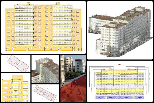
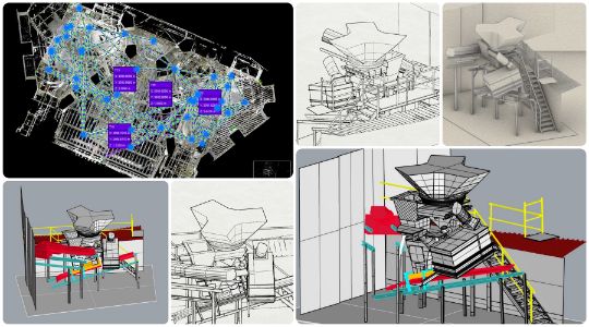
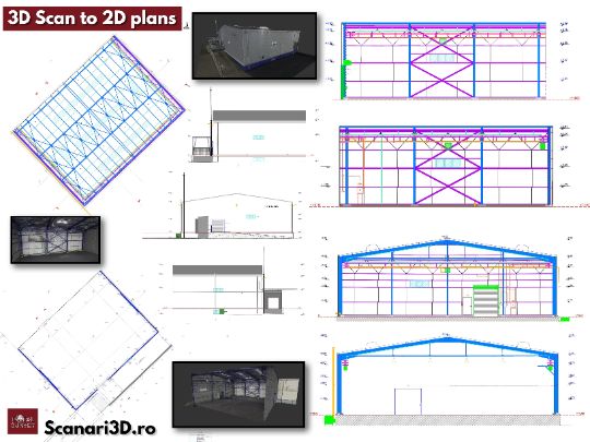
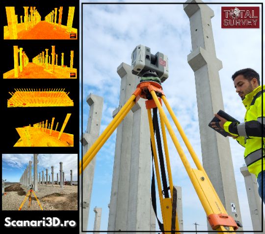
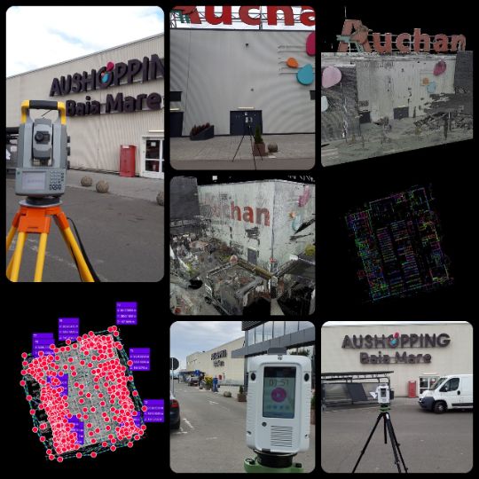
Baia Mare, jud. Maramures

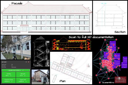
Scan to generate as build plans, Auchan shopping center

Auchan Baia Mare hypermarket has a total area of approximately 19200sqm. Digitization was done by 3D scanning. A total of 547 outdoor scanning stations were performed. The "cloud to cloud" recording resulted in an overall accuracy of +/- 3.6mm.

Scan 20 hours | Registration 16 hours

Predeal, jud. Prahova

3D scanning for villa restoration project

The scan was performed to provide the design company with the cloud of RGB points in order to prepare the 3D model and generate the level plans, sections and elevations.

  • low and medium color resolution scanning
  • 110 indoor and outdoor scanning stations
  • indoor and outdoor cloud-to-cloud recording
  • inner-outer connections on spheres
  • 138 links, 1.57 billion points
  • 3.4mm recording accuracy

Scanning & Registration & Export - 20 hours

Calarasi, jud. Calarasi

Plans, sections and elevations of the gym

The 3D scanning was performed with the Leica RTC360 laser scanner, the purpose of the scan was to generate level surveys, facade plans and longitudinal and transverse sections in order to carry out the DTAC project.

  • scan average resolution 6mm @ 10m
  • indoor & outdoor color scanning - 360 HDR panorama
  • cloud-to-coud recording & spheres & targets
  • georeferenced in Stereo '70 system

Scanning & Recording & 2D plans - 36 hours

ScanToBIM
Otopeni, jud.Ilfov

3D modeling of the interior of the house

Interior scanning performed with the Leica RTC360 laser scanner. # 3D scanning was performed for a design firm in order to make a three-dimensional model of the living area for further design of this area.

  • 6 scanning stations with average resolution 6mm @ 10m
  • cloud-to-cloud registration
  • recording accuracy +/- 1mm
  • georeferencing on black & white targets precision +/- 3mm
  • 3D modeling of the point cloud

Scanning & Recording & Modeling - 6 hours
Scanari 3D - stalpi de beton
Cernica, jud.Ilfov

3D scans for checking the installation of concrete columns

The verification of the planimetric and altimetric installation of the concrete pillars was performed using the scanning method with Leica # RTC360.

  • 17 high density scanning stations (3mm @ 10m)
  • registration and georeferencing by the combined method: spheres and cloud-to-cloud.
  • Final precision of the network: +/- 3mm

Scanning & Recording & Installation Report - 6 hours
Scanare3D pentru fatade
Sector 1, Bucuresti

3D scanning to generate elevations

The scan was performed for the generation of orthophotoplanes of the facades in order to be vectorized for the production of their surveys.

  • to cover both facades, scans were performed from 7 positions
  • the general accuracy obtained after registration was 3.9mm.

Scanning & Recording & Facade Surveys - 7 hours
Scanare centru comercial
Satu Mare, jud.Satu Mare

Generate 2D surveys as build Auchan shopping center

The shopping center has a total area of approximately 22000sqm. Digitization was done by # scan3D with #laserscannerLeica # RTC360.

  • 414 outdoor and indoor scanning stations.
  • "cloud to cloud" recording, general accuracy of +/- 3mm.

Scan in 16 hours 💪
Scanare monument istoric
Sinesti, Ialomita

Scan for restoration of historic monument building

For this restoration project we helped the designers with 3D scanning, generation of facade orthophotoplanes and vectorization of elevations.

Scanning & recording & elevations - 10 hours
Scanare pentru verificare structura beton
Pipera, jud. Ilfov

Scanning to check the concrete structure

The purpose of the 3D scan was to generate the point cloud that was georeferenced in the building's designed system. The verification of the concrete structure was done by comparing the designed elements (CAD) with the executed elements (point cloud). The total area scanned was 6000sqm.

Scan - 6 hours 💪
Scanare3D pentru determinare cantitati
Ploiesti, Prahova

Determination of quantities of hydro and thermal-insulating material

3D scanning was performed to determine the quantities of thermal and waterproofing material of 4 thermally rehabilitated buildings. The following quantities were determined:

  • terrace waterproofing material
  • thermal insulation material walls
  • thermal insulation material parapets
  • carpentry windows

30 hours (scan & registration & elevations)
ScanToBim industrial area
Campulung, Arges

ScanToBim industrial area

3D scanning with Leica RTC360 inside an industrial area in order to generate a #3Dmodel of a sorter for designing and subsequently upgrading the equipment.

  • 40 scanning stations, sphere and cloud to cloud registration
  • 3.5mm registration precision, 2.3mm georeferencing precision
  • 3D modeling of a sorter
  • total scanning time - 3.5 hours
  • total import & registration time - 10 hours
  • total 3D modeling time - 25 hours

🎦 View this 3D Model🎦

Scanning & Registration & Modeling - 33.5 hours
3DScan for windows
Bucuresti

3DScan for windows design

We performed a 3D scan of the built concrete structure in order to provide the designer with the as-build facade drawings necessary for the design of the windows closures.

  • laser scanner used Leica RTC360
  • sphere registration (90%) and cloud to cloud (10%)
  • georeferencing on black & white targets

3D Scan & Drawings - 14 hours
SCAN-MODEL-STAKEOUT

1️⃣SCAN 2️⃣MODEL3️⃣STAKE OUT

Because we like the challenges and projects from A to Z for this work we made:

◼️ 3D scanning concrete structure - with laser scanner Leica RTC360

◼️ point cloud modeling for 3D model generation (BIM)

◼️ stake out the axes of the building on the facades

This project was made for the design of glass enclosures and stake out in the field of the elements necessary for the assembly.

🎦 View this 3D model🎦

Scan to As Built

3D scanning for as built plans

Industrial premises and offices for which a 3D laser scan was performed with the Leica scanner # RTC360 in order to generate as built plans for : floors, facade and cross sections.

◼️ 5400 sqm
◼️ 662 scanning stations
◼️ 1096 links
◼️ registartion on spherical targets, B&W and cloud to cloud
◼️ +/- 3.2mm registartion accuracy
◼️ 50 hours scan time
◼️ 40 hours processing time at the office
90 hours : scan & plans
3D Scanning for 3D inventory
Cernica, jud.Ilfov

3D Scanning for 3D inventory

Fashion House Group is building in the eastern part of Bucharest a new shopping center with opening scheduled for 2021. Our teams perform 3D scanning of the entire building for 3D inventory and for as built plans necessary to determine the surfaces according to the #BOMA standard and for the registration of the construction in the Land Book.

  • GLA - 12590 sqm
  • 93 stores
  • 868 parking spaces

Scan to BIM - Hilton Athenee Palace
Hilton, Bucuresti

⭐ Scan to BIM - Hilton Athenee Palace ⭐

An emblematic hotel of Bucharest located between the Roman Athenaeum and the Royal Palace. This building, over 100 years old, has gone through two World Wars, as many catastrophic earthquakes, it was bombed, it was fired with a machine gun at the Revolution but it survived and is today superb and imposing. The new wing of the hotel is in the process of modernization and we helped with #3Dscan and #3Dmodel for beams and floors.

Scan & 3D model - 25 hours
Scan to BIM
Cornetu, jud.Ilfov

3D Model for design

3D scanning with Leica RTC360 laser scanner and point cloud processing for 3D - BIM model generation.

  • 75 scanning stations
  • 143 links
  • registration with sphere and C2C
  • georeferencing on B&W targets
  • 3.2mm global network error

The 3D model was handed over to the architecture company in .dwg and .obj format.

🎦 View this 3D model 🎦

3DScan & 3DModel - 30 hours
3D Model - BIM - attic and terrace

3D Model - BIM - attic and terrace

This project involved a 3D scan of an attic and terrace for an apartment located in the center of Bucharest. The scan was performed at medium resolution with spheres registration and georeferencing on black and white targets. The resulting point cloud was modeled for generation of the 3D - BIM model that was handed over to the interior design and architectural company for the redevelopment of this space.

  • 14 scanning stations
  • registration with spheres
  • georeferencing with B&W targets
  • global network error +/-2.2mm

🎦 View this 3D model 🎦

Sector 1, Bucuresti
3D scanning for school modernization
Fagaras, jud.Brasov

3D scanning for school modernization

Interior and exterior 3D scanning performed with Leica #RTC360 to generate the complete 2D documentation required in the design process for school modernization.

  • 2900 sqm total area
  • 300 scanning stations
  • 611 network links
  • sphere and C2C registration
  • georeferencing with B&W targets
  • +/- 3.8mm accurate network

The following documents were handed over: situation plan, level 2D drawings, facade plans and sections.

Scan & 2D drawings - 60 hours
3D scanning with photogrammetry

Volume determination of stored waste

3D scanning by photogrammetric methods to determine the volumes of stored waste.
  • Drone used DJI Phantom 4 Pro
  • 397 aerial images
  • 1.34cm GSD
  • 13 - 3D control points
  • 1 - 3D checkpoint
The point clouds resulted from the photogrammetric processing was filtered to eliminate the points that do not belong to the "ground", the volume calculations were performed using specialized software.
Oltenita, Calarasi
AFI Tech Park 2

AFI Tech Park 2 atrium structure verification

3D scanning to check the atrium structure in order to design the windows closures. Equipment used Leica RTC360.


✅ 16 scanning stations
✅ scan at medium resolution 6mm @ 10m
✅ 45 network links
✅ registration accuracy +/- 3 mm
✅ C2C registration
✅ georeferencing on B&W targets


2D surveys in dwg and pdf format were handed over for each level of the executed beams and concrete slabs.

2D Scanning & 2D plans - 8 hours
Scanare centru comercial

3D Scanning & Full 2D pack

3D scanning for 1150sqm house for generation of: level plans, roof plan, elevations plans and cross sections.
  • medium and low resolution scanning
  • BW scanning inside & color scanning for outside
  • C2C registration and spherical targets
  • 219 scanning stations
  • 363 network links
  • 4.5mm network vector error
3D Scanning & 2D pack - 56 hours
3D Scanning Heritage

3D scan for historic building

The purpose of the 3D scan was to produce ✍🏼 2D as built documentation in order to start the design procedure for the restoration and consolidation of the church ⛪ Cascioarele.


3D scan parameters:
◾ average resolution 6mm @ 10m
◾ 90 scanning stations
◾ +/- 5mm registration error
◾ +/- 7mm georeferencing error
Cascioarele, Jud.Giurgiu
Scanare centru comercial

3D scanning industrial deposit

The purpose of this 3D scanning project was to produce accurate as buit 2D deliverables. 3D scanning was realized with the Leica #RTC360 laser scanner. 3D scanning parameters:

🔳 average resolution 6mm @ 10m
🔳 sphere and cloud-to-cloud registration
🔳 registration accuracy +/- 2.4mm

As built deliverables:

✔️ 2D Survey plan
✔️ 2D roof plan
✔️ 2D interior cross sections
✔️ 2D façade plan
Ploiesti, Jud.Prahova
Historical monument facade plans

Historical monument facade plans

This historical monument building is located in Bucharest old center near the National Bank of Romania. The building will be rehabilitated and transformed into a class A space, with office and retail spaces. 3D scanning was performed to generate interior surveys and facade plans. 3D scan parameters:

  • 154 scan stations
  • C2C and sphere registration
  • 3.4mm registration accuracy
  • 6mm georeferencin gaccuracy
Old Center, Bucharest

Scan to Model for slope surface determination

Triumf Hotel located in the center of Bucharest has a long history, it was built by the National Bank of Romania in 1937 and transformed into a hotel in 1950. On September 12, 2020, the roof of the hotel was partially destroyed by fire. At this moment the hotel is in an extensive renovation process. 3D scanning of the roof was performed with the Leica #RTC360 laser scanner to accurately determine its sloping surface.

View 3DModel 👇🏻
https://skfb.ly/oqN7L
Tank Volume Determination

Tank volume determination

3D Model of an underground rainwater retention basin that serves a shopping center in Bucharest. The measurements were made for determination of total volume / storage capacity of the tank, and were performed classically (with the total station Trimble S5), due to wastewater remaining on the bottom of the basin.

View 3D model of the tank

Scanare centru comercial

3D Scanning for Design

3D scanning with Leica RTC360 laser scanner for generating of as built plans for new building design: level plans, roof survey plan, facade plans and cross sections.

  • medium and low resolution scanning
  • B&W indoor and outdoor scanning
  • C2C registration and spherical targets
  • 96 scanning stations
  • 191 network links
  • 4.1mm global network vector error

3D scanning for building expertise

3D scanning for building expertise

3D scanning with Leica RTC360 laser scanner for generation of as built plans and characteristic sections for two buildings structural expertise.

  • medium and low resolution scanning
  • interior and exterior scanning
  • C2C registration and georeferencing
  • 335 scanning stations
  • 611 network links
  • +/- 2.2mm network error

3DScanning

🔭 Scanning 3D of metal pillar structure 🏗️

This work was performed to verify the integrity of the metal structure ⛑️ and to confirm the safety in operation.


🟢 Leica #RTC360 laser scanner
🟢 high resolution scan 3mm@10m
🟢 registration with spherical targets
🟢 georeferencing on B&W targets
🟢 deliverable: front, side and top view sections


#TotalSurvey #FasterBetterSmarter #Scanare3D #3DScanning

3D Scanning

3D scanning for building expertise project

We used 3D scanning technology to generate 2D as-built deliverables of an construction in order to prepare the technical expertise project of the building.

2D deliverables:

  • interior plans
  • facade plans
  • longitudinal section
  • cross section
Scanare centru comercial

3D scanning - facade plans of a historic monument building

The 3D scanning measurement method was used to generate the facade surveys of a historic monument building located in Bucharest. A total of 64 medium (6mm @ 10m) and high resolution (3mm @ 10m) scanning stations were performed using the Leica RTC360 laser scanner.

2D deliverables:

  • facade plans - 1:50 scale

digitization

Digitization of the episcopal ensemble Curtea de Arges

The digitization project involved a 3D scan of the following objectives: the episcopal palace, the wooden church, the annexes, the information center and the enclosure wall, which were restored following an extensive reconstruction program.

To digitize these objectives, 1250 color 3D scanning stations were made at 3mm@10m and 6mm@10m resolutions.

The five objectives of the episcopal ensemble Curtea de Argeș monastery included in the digitization project have an area of over 15500sqm.

FIND OUT MORE ABOUT THIS PROJECT

Scanare centru comercial

Scanning & Modeling & 2D Plans - shopping center

3D scanning project for store space design in Park Lake Mall. The 3D scan was performed with the Leica RTC360 scanner. To the design company we delivered:

  • 2D plans
  • 3D model
See the 3D model here.
Building facade scanning

Facade elevations - historical building

Due to the high degree of detail, drawing the facades of historical buildings is a challenge. With #3D scanning technology this operation is much simplified. To generate the elevations of the facade, we used the Leica RTC360 laser scanner. The exterior of the historic building was scanned, a total of 45 3D scanning stations were made using scanning resolutions of 6mm@10m and 3mm@10m. The point cloud was registered and georeferenced and later it was processed to generate the elevations of the facade.

Checking the installation of concrete pillars

Checking the installation of concrete pillars

Production hall with a moving bridge with an area of ​​2800 square meters. 3D scanning technology was used to verify the installation of the concrete pillars.
📌 Fundulea, Calarasi county
🏚️ Production hall
📍 29 3D scanning stations
🔗 118 links in the network
⏱️ 2.5 scanning time | 8 hours import, processing and deliverable generation
✅ Network accuracy +/- 3.10mm
📁 Deliverables: planimetric plans
The pont cloud was processed to generate the planimetric plans which includes sections of the pillars at different heights. Thus, the differences compared to the projected position as well as verticality deviations were determined.
Scanare 3D Hanul Poienita

Poienita Inn - facade plans


Preserving part of the history of its origins, Poienita Inn is still today an exceptional place that also meets the expectations of its visitors. Surrounded by a beautiful corner of nature, the Inn is located near the town of Râmnicul Sărat. We helped with this project with #3DScanning to generate the facade elevations plans.
📌 Ramnicu Sarat, Buzau

🏚️ Hotel & Restaurant

📍 50 3D scanning stations

🔗 122 links in the network

⏱️2h30m scanning time

✅ 4.2mm registration error

📁 Deliverables: facade plans
3D scanning for the generation of 2D plans - Urziceni railway station

3D scanning for the generation of 2D plans - Urziceni railway station

Urziceni railway station is an important railway hub that connects several major cities in the country. Our company has carried out a 3D scan to prepare the 2D plans of the building (level surveys, façade surveys, and cross-sections), necessary in the rehabilitation process of the building.

📌 Urziceni, jud. Ialomita
🏚️ Urziceni railway station
📍 122 scanning stations
🔗 282 links in the network
⏱️ 4 hours of effective scanning time
✅ Network accuracy +/- 3.5 mm
📁 Deliverables: level surveys, façade surveys, cross-sections.

Restoration of Postavari Bastion

In recent years, 3D scanning has become an increasingly popular technique in the field of restoration and conservation of historical monuments. This technology allows archaeologists and restorers to obtain a very detailed and accurate picture of the structure of a historical object, as well as its damage, without having to manipulate the object itself. The 3D scan of the bastion has allowed the creation of a complete digital image of it, which can be used to document its current state and to plan possible conservation interventions in the future. This technique can also be applied to other historical sites around the world, allowing specialists to restore and protect historical heritage for future generations.

Revealing the past of historical monuments through 3D scanning

In recent decades, 3D scanning has become an innovative technology that brings a new breath to the field of conservation and restoration of historical monuments. This advanced technology enables accurate digital representations of historic structures and objects, giving us an immersive insight into our past. 3D scanning brings significant benefits to the preservation and promotion of cultural heritage, opening up new opportunities for research, restoration and education.

reliable for